
The city of Manchester is located 190 miles north west of the English capital, London. The city lies some 30 miles in land but, when this location became a serious impediment to trade, a canal capable of accommodating ocean-going ships was constructed. The Manchester Ship Canal opened in 1894 and for much of the 20th Century Manchester was an important "sea-port".
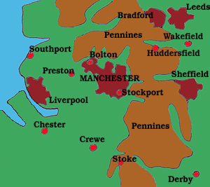
The city lies on relatively flat ground backed in the north and east by the Pennine hills. A number of important rivers flow south and west out of the hills not only providing the city and its satellites with water and power but creating deep valleys which offered transportation routes through the hills. Packhorse trails became roads and now motorways traverse these moorland hills.
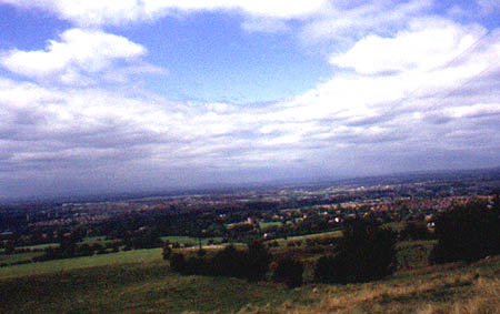
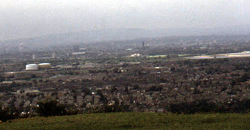
When I lived in Manchester in the 1950s the primary source of heat and power generation was coal from the nearby coal fields of Lancashire and Yorkshire. The Pennine hills which rose above the city were invisible to us and a good bus ride away. Sitting up on the hills in Lyme Park, Manchester was located as a cloud of smoke in the distance. When I returned to the city in the 70s and 80s the effect of the "Clean Air Act" was clearly evident. Now you could stand on St. Mary's Gate in the heart of the city and see the Pennines beyond the Cathedral. Similarly you could stand on Werneth Low outside of Romiley and survey the urban scene below from Stockport to your left, through the city centre and beyond to the Audenshaw reservoirs, Hyde and Hattersley on your right.
As a child I was taken by my Dad to a coal yard in Castlefield beneath the railway viaducts carrying the rail line out of Central Station. This was long before this area of canals, railway lines, warehouses and commercial buildings became the trendy community of condominiums, museums and restaurants it is today. We wandered in unannounced and univited so he could show me a piece of stone wall among the brickwalls and coal heaps. This he told me was all that was left of the Roman fort that gave the area its name.
If you go there today you can see a very new
looking reconstruction of one of the stone gateways of the fort
which was built in the 3rd century to replace two earlier turf
and wood forts dating back to 79AD. At that time the fort sat
at a major junction in Roman Britain where the east - west route
from York to Chester intersected with the north-south route from
Ribchester to Hadrian's Wall. The 1.6 hectare fort known as Mancunio
or Mamucium gave the city its name. The Roman word "castrum"
meaning fort became "chester" and English cities and
towns with chester as part of their name were Roman military settlements,
hence "Man - chester". In the Anglo-Saxon Chronicle
it was Mameceaster and in the Domesday Book, Mamecestre.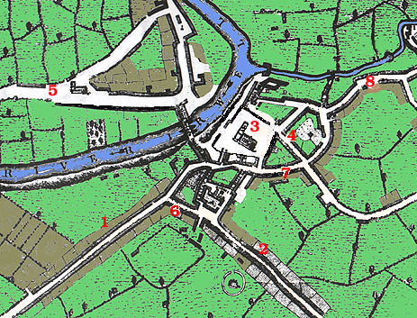
The Romans left in 140 AD and the area was overun by Anglian and Danish invaders. Prior to the Norman Conquest the area which is now Manchester and the Lancashire Plain was occupied by the Mercian Angles.
The early maps of Manchester showed a very simple settlement around the confluence of the rivers Irk and Irwell with Salford on the north side of the Irwell and Manchester to the south.
The map opposite dates from 1650. The road entering the city from the west - #1 - is Deansgate. At #6 on the map Deansgate is met by St. Mary's Gate which leads southwards into Market Street -#2. Christ Church - #3 - holds a prominent position in the heart of this medieval city in a location occupied today by the Cathedral. Fennel Street - #4 - leads away from the church to Hanging Ditch - #7.
Just below #6 on the map is a field which was in those days known as Acresfield. It was the site of the annual fair and today is St. Anne's Square. Across the river, at #5 on the map, is Trinity Chapel located on what is today Chapel Road.
|
|
 |
|
|
|
 |
 |
|
|
|
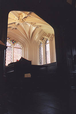
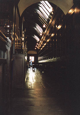
Sitting in the corner created by the Irwell and the Irk was Humphrey Chetham's Hospital School and Hugh Oldham's free grammar school. Nearly 500 years later the buildings remain. The manor house built by Humphrey Chetham became a college for priests, then a prison used by the Parliamentary forces in the Civil War and finally a school for "the children of honest, industrious and painful parents". Today the school is Chetham's School of Music but Chetham's Library remains, the oldest public library in the English speaking world.


 |
 |
|
|
|