|
As a child I was taken by my Dad to a coal yard in Castlefield beneath the railway viaducts carrying the rail line out of Central Station. This was long before this area of canals, railway lines, warehouses and commercial buildings became the trendy community of condominiums, museums and restaurants it is today. We wandered in unannounced and univited so he could show me a piece of stone wall among the brickwalls and coal heaps. This he told me was all that was left of the Roman fort that gave the area its name. If you go there today you can see a very new looking reconstruction of one of the stone gateways of the fort which was built in the 3rd century to replace two earlier turf and wood forts dating back to 79AD. At that time the fort sat at a major junction in Roman Britain where the east - west route from York to Chester intersected with the north-south route from Ribchester to Hadrian's Wall. The 1.6 hectare fort known as Mancunio or Mamucium gave the city its name. The Roman word "castrum" meaning fort became "chester" and English cities and towns with chester as part of their name were Roman military settlements, hence "Man - chester". In the Anglo-Saxon Chronicle it was Mameceaster and in the Domesday Book, Mamecestre. The Romans left in 140 AD and the area was overun by Anglian and Danish invaders. Prior to the Norman Conquest the area which is now Manchester and the Lancashire Plain was occupied by the Mercian Angles. |
| The early maps of Manchester showed a very simple settlement around the confluence of the rivers Irk and Irwell with Salford on the north side of the Irwell and Manchester to the south. |
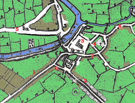 |
| The map above dates from 1650. The road entering the city from the west - #1 - is Deansgate. At #6 on the map Deansgate is met by St. Mary's Gate which leads southwards into Market Street -#2. Christ Church - #3 - holds a prominent position in the heart of this medieval city in a location occupied today by the Cathedral. Fennel Street - #4 - leads away from the church to Hanging Ditch - #7 Just below #6 on the map is a field which was in those days known as Acresfield. It was the site of the annual fair and today is St. Anne's Square. Across the river, at #5 on the map, is Trinity Chapel located on what is today Chapel Road. |