|
The Manchester City Council website
describes the Longsight Ward as, "... a
residential suburb situated less than three miles
south of Manchester City Centre on the 'A6
corridor' route, which stretches from the City
Centre through Ardwick to Longsight. The ward now
naturally divides into four areas or
neighbourhoods - Northmoor Road, Victoria Park,
Hamilton Road and the District Centre." It
is bounded by Daisy Bank Road and Kirkmanshulme Lane
in the North, Pink Bank Lane in the East, Old Hall
Lane in the South and Beresford Road and Anson Road in
the West. Below you can see the boundary
superimposed on an old map. 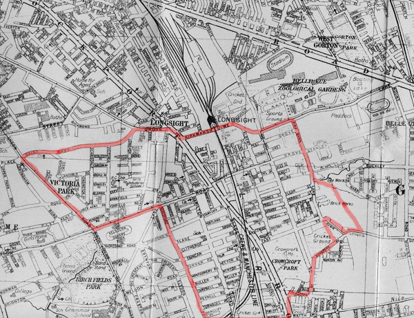 However, this wasn't Longsight when I
lived there in the 1950s. I lived on Holt
Street, in the shadow of the Daisy Mill, one of the
grey terraced streets between Stockport Road and the
railway. Apparently that is now Ardwick. When Gay Sussex wrote "Longsight Past
and Present" in 1983, Longsight was described as an "...
odd butterfly shaped suburb", which "...
in some ways ... is the bits left over after the
older communities of Rusholme, Gorton and Ardwick
had established their communities." The map below shows the boundaries of the electoral ward of Longsight, as it was on a 1982 map from the City of Manchester Planning Department. The district was then defined by Hyde Road, Grey Street, Stockport Road, Plymouth Grove, Richmond Grove, Hathersage Road, Anson Road, Dickenson Road, Beresford Road, Old Hall Lane, Stockport Road, East Road, Pink Bank Lane, Nutsford Vale, Buckley Road and Mount Road. 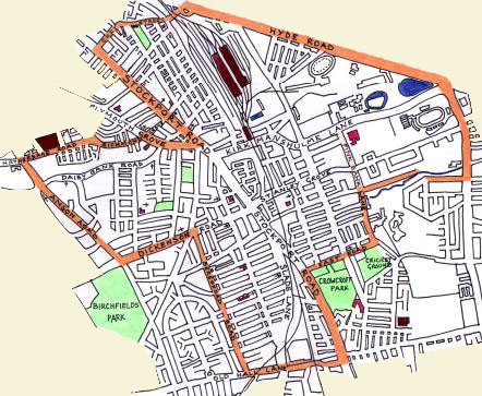 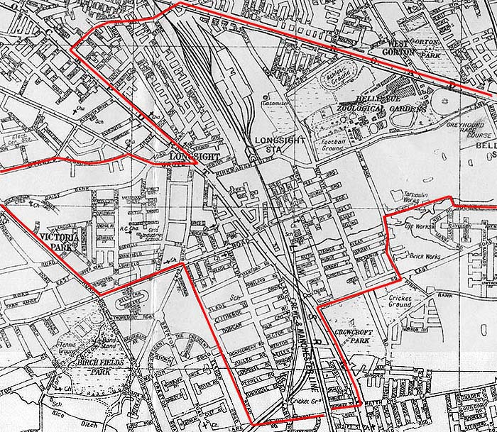 This map segment is shown with the permission of Eric Rowland http://www.artus-fh.co.uk/index.html *********************** These boundaries may have relevance
for electoral purposes but the people were
associated with schools, businesses, churches and
even parks that were located beyond the border in
Chorlton on Medlock, Ardwick, Rusholme and Gorton.
For that reason this study of Longsight will examine
these links and describe places that were infact
beyond our border.
Longsight was never subdivided in any
formal way but, in fact, there were a number of
distinct communities within the district. For the
purposes of looking at the geography of the district I
intend to divide it into the 4 segments shown on the
map below. I will be describing all of them
despite the fact that I have strayed into Levenshulme
and what is now Ardwick. 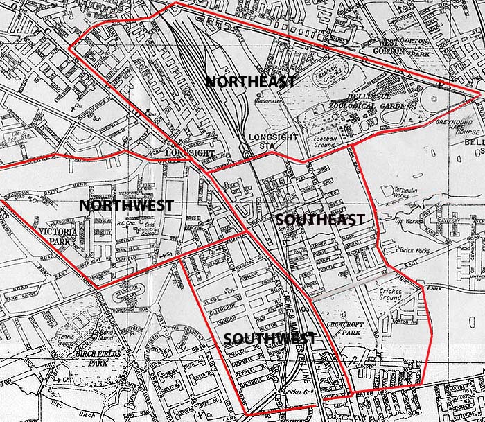
The Northeast is bound by Grey Street in the North and Kirkmanshulme Lane in the South, Stockport Road in the west and Hyde Road in the east. The area is bisected by the railway and includes the former Belle Vue Zoological Gardens. The Northwest is bound by Hathersage Road, Richmond Grove and Plymouth Grove in the north, Stockport Road in the east, Dickenson Road in the south and Anson Road in the west. It includes retail shopping areas along both Stockport Road and Dickenson Road and the eastern portion of Victoria Park. The Southwest is bound by Dickenson Road in the north, Old Hall Lane in the south, Beresford Road in the west and Stockport Road in the east. It includes Slade Hall and is bisected by Slade Lane. The Southeast is bound by Stockport Road
in the west and Pink Bank Lane in the east. The
northern boundary is defined by Kirkmanshulme Lane
and the south by Mathews Lane. I have prepared a brief tour of each
of these areas. These are not intended to be
in-depth studies more a brief introduction. Much
more detailed information is to be found by selecting
other items on the Longsight Memories main menu. |